If you need something repaired, built, maintained or installed - Sir Fix Alot is the one to call
Property Repair Services
we are only a phone call away
832-378-7338
CALL US NOW
for a free phone consultation


Alief, Houston
Zip codes: 77072, 77099
Alief is a large suburban community in southwestern Harris County, Texas, United States, mostly within the city limits of Houston. The Alief Community Association defines the boundaries of Alief as, Westheimer on the north, Sam Houston Tollway on the east, Fort Bend County Line on the west and Interstate 69/U.S. Highway 59 on the south, while the Alief Independent School District boundaries extend as far east as Gessner in some places. Portions of Alief are in Southwest Houston while other portions of Alief are within unincorporated Harris County.
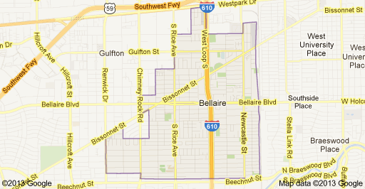
Bellaire, Texas
Zip codes : 77071, 77074, 77081, 77401, 77402
Bellaire is a city in southwest Harris County, Texas, United States, within the Houston–Sugar Land–Baytown metropolitan area. As of the 2010 U.S. Census, the city population was 16,855 and is surrounded by the cities of Houston and West University Place.
Bunker Hill Village, Texas
Zip codes: 77024
Bunker Hill Village is a city in Harris County, Texas, United States, part of Houston–The Woodlands–Sugar Land metropolitan area. The population was 3,633 at the 2010 census. It is part of a collection of upscale residential communities in west Houston known as the Memorial Villages.


Downtown, Houston
Zip Codes: 77001, 77002, 77003, 77004, 77010
Downtown is the largest business district in Houston, Texas, located near the geographic center of the metropolitan area at the confluence of Interstate 10, Interstate 45, and Interstate 69. Downtown has been the city's preeminent commercial district since its founding in 1836.
Today home to nine Fortune 500 corporations, Downtown contains 50 million square feet of office space and is the workplace of 150,000 employees. Downtown is also a major destination for entertainment and recreation. Nine major performing arts organizations are located within the Theater District at prominent venues including Alley Theater, Jones Hall, and the Wortham Theater Center. Two major professional sports venues, Minute Maid Park and the Toyota Center, are home to the Houston Astros and Houston Rockets, respectively. Discovery Green, located on the east side of the district adjacent to the George R. Brown Convention Center, anchors the city's convention district.
Geographically, Downtown is bordered by East Downtown to the east, Third Ward to the south, Midtown to the southwest, Fourth Ward to the west, Sixth Ward to the northwest, and Near Northside to the north. The district's streets form a strict grid plan of approximately 400 square blocks, oriented at a southwest to northeast angle.
Downtown Houston is a 1,178-acre area bounded by Interstate 45, Interstate 69/U.S. Highway 59, and Interstate 10/U.S. Highway 90. Several sub-districts exist within Downtown.
Energy Corridor, Houston
Zip Codes: 77043, 77077, 77079, 77084, 77094
The Energy Corridor is a business district in Greater Houston, Texas, located on the west side of the metropolitan area between Beltway 8 and the Grand Parkway. The district straddles a 7-mile stretch of Interstate 10 (the Katy Freeway) from Kirkwood Road westward to Barker Cypress Road and extends south along Eldridge Parkway to Briar Forest Drive. Parts of the district overlap with the Memorial area of Houston. The district is located north of Westchase, another major business district of Houston, and east of Greater Katy.

Galleria (Uptown), Houston
Zip Codes: 77056
Uptown (more commonly called The Galleria Area) is a business district in Houston, located 6.2 miles, west of Downtown and is centered along Post Oak Boulevard and Westheimer Road (FM 1093). The Uptown District is roughly bounded by Woodway Drive to the north, the I-610 (West Loop) to the east, Richmond Avenue to the south, and Yorktown Street to the west. It covers 1,010 acres.
More than 30 million visitors each year seek the dynamic & fine shopping environment uniquely offered by The Galleria, Texas’ largest shopping center and fourth largest domain nationally. International guests and Houstonians blend seamlessly in the center while on shopping excursions or entertaining guests at one of the signature eateries.
Spanning 2.4 million square feet of space, housing 400 fine stores and restaurants, two high-rise hotels, and three office towers, The Galleria is Houston’s most popular retail and tourist destination, meeting every style and taste. A plethora of amenities, including a full-size ice rink for recreational and figure skating, a state of the art children’s play area, two swimming pools, three full-service national and international banks, two tailor shops, more than seven beauty salons, and a post office, continually serve a wide range of shopper delights. More than 7,000 business professionals in the adjoining office towers, offering 1.1 million square feet of office space, reap the benefit and convenience of having The Galleria just a short walk away.

Greenway Plaza, Houston
Zip Codes: 77046
Greenway Plaza is a business district located along Interstate 69 (U.S. Highway 59) within the Interstate 610 loop in southwestern Houston, Texas, 5 miles west of Downtown and 3 miles east of Uptown. The district is located immediately west of Upper Kirby, north of West University Place, and south of River Oaks. The Greenway Plaza development is part of a larger neighborhood, Greenway/Upper Kirby, which covers a 2.97-square-mile area roughly enclosed by Westheimer Road to the north, Bissonnet Street to the south, Uptown Houston to the west, and Shepherd Drive to the east. In 2015, Greenway/Upper Kirby had an estimated population of 21,120 and a population density of 7,111/sq mi.

Gulfton, Houston
Zip Codes: 77081
Gulfton is a community in Southwest Houston, Texas, United States that includes a 3.2 sq mi group of apartment complexes. It is located between the 610 Loop and Beltway 8, west of the City of Bellaire, southeast of Interstate 69/U.S. Highway 59, and north of Bellaire Boulevard.

Heights, Houston
Zip Codes: 77008, 77009
Houston Heights (often referred to simply as "The Heights") is a community in northwest-central Houston, Texas, United States. "The Heights" is often referred to colloquially to describe a larger collection of neighborhoods next to and including the actual Houston Heights. However, Houston Heights has its own history, distinct from Norhill and Woodland Heights.

Jersey Village, Texas
Zip Codes: 77040, 77041, 77065
Jersey Village is a city in west-central Harris County, Texas, United States, located at U.S. Highway 290, Farm to Market Road 529, and the Southern Pacific Railroad. The city is located in the Houston–Sugar Land–Baytown metropolitan area. The population was 7,620 at the 2010 census.
According to the United States Census Bureau, the city has a total area of 3.5 square miles, of which 3.4 square miles is land and 0.04 square miles, or 0.87%, is water.

Memorial, Houston
Zip Codes: 77024, 77079
The Memorial area of Houston, Texas is located west of Downtown, northwest of Uptown, and south of Spring Branch. The Memorial Super Neighborhood, as defined by the City of Houston, is bounded by Buffalo Bayou to the south, Barker Reservoir to the west, the Katy Freeway (Interstate 10) to the north, and the Memorial Villages (Spring Valley Village, Piney Point Village, Bunker Hill Village, Hedwig Village, Hilshire Village and Hunters Creek Village), a contiguous group of independent municipalities, to the east. The area is also home to a number of dense mixed-use districts, including Memorial City, Town & Country Village, and CityCentre. A large portion of the Energy Corridor, a major business district populated by many energy corporations, overlaps with west Memorial along Eldridge Parkway.

Meyerland, Houston
Zip Codes: 77096
Meyerland is a 6,000-acre community in southwest Houston, Texas, outside of the 610 Loop and inside Beltway 8. The neighborhood is named after the Meyer family, who bought and owned 6,000 acres of land in southwest Houston. The area is also home to Meyerland Plaza, a large outdoor shopping center.

Mission Bend, Texas
Zip Codes: 77082, 77083
Mission Bend is a census-designated place (CDP) around Texas State Highway 6 within the extraterritorial jurisdiction of Houston in Fort Bend and Harris counties in the U.S. state of Texas; Mission Bend is 4 miles northwest of the city hall of Sugar Land and 20 miles southwest of Downtown Houston. The population was 36,501 at the 2010 census.

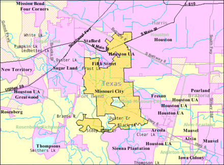
Missouri City, Texas
Zip Codes: 77459, 77489
Missouri City is a city in the U.S. state of Texas, within the Houston–The Woodlands–Sugar Land metropolitan area. The city is mostly in Fort Bend County, with a small portion in Harris County. As of the 2010 census, the city had a population of 67,358, up from 52,913 in 2000. The population was estimated at 74,139 in 2015.
Montrose, Houston
Zip Codes: 77006
Montrose is a primarily residential neighborhood located in the Neartown area of Houston, Texas, United States. Established in 1911, the neighborhood is a demographically diverse area with renovated mansions, bungalows with wide porches, and cottages located along tree-lined boulevards. Montrose has been called the "Heart of Houston, the "strangest neighborhood east of the Pecos, and was named one of the "ten great neighborhoods in America" in 2009.

Museum District, Houston
Zip Codes: 77004, 77005, 77006, 77030, 77098
The Houston Museum District is an association of 19 museums, galleries, cultural centers and community organizations located in Houston, Texas, dedicated to promoting art, science, history and culture. The Houston Museum District currently includes 19 museums that recorded a collective attendance of over 8.7 million visitors a year. Bordered roughly by Texas State Highway 288, Hermann Park, U.S. Route 59, and the Texas Medical Center, the Museum District specifically refers to the area located within a 1.5-mile radius of the Mecom Fountain in Hermann Park.

Northside Houston
The Northside of Houston consists of several Historic neighborhoods to include Houston Heights, Near Northside, The Fifth Ward, The Historic Sixth Ward, Kashmere Gardens, Trinity Gardens, Homestead, Acres Homes, the East Aldine District and Greenspoint. Residents of these neighborhoods commonly refer to this area as " Northside " Many suburban Houstonians confuse the term to be associated with the suburbs of North Houston such as Spring, FM 1960 or The Woodlands.


Piney Point Village, Texas
Zip Codes: 77024
Piney Point Village is a city in Harris County, Texas, United States. As of the census of 2010, there were 3,125 people, 1,064 households, and 945 families residing in the city. Piney Point Village is the wealthiest place in Texas, as ranked by per capita income. It is part of a collection of upscale residential communities in west Houston known as the Memorial Villages.
River Oaks, Houston
Zip Codes: 77019, 77027
Nestled between The Galleria and Montrose neighborhoods, is the shaded oasis of River Oaks. The luxurious area brings foodies, shoppers, and visitors for food, activities, and gorgeous, mansion-filled neighborhoods.
River Oaks is a residential community located in the center of Houston, Texas, United States. Located within the 610 Loop and between Downtown and Uptown, the community spans 1,100 acres. Established in the 1920s by brothers William and Michael Hogg, the community became a well-publicized national model for community planning. Real estate values in the community range from $1 million to over $20 million. River Oaks was also named the most expensive neighborhood in Houston in 2013.

Sharpstown, Houston
Zip Codes: 77036
Sharpstown is a master-planned community in the Southwest Management District (formerly Greater Sharpstown), Southwest Houston, Texas It was one of the first communities to be built as a master-planned, automobile centered community and the first in Houston. Frank Sharp (1906–1993), the developer of the subdivision, made provisions not only for homes but also for schools, shopping and recreation areas.

Southeast Houston
Southeast Houston is a district in Houston, Texas, United States. The Greater Southeast Management District (GSMD) manages the area. Communities within the district include the Third Ward, Texas Medical Center, Riverside Terrace, University Oaks, and Washington Terrace.

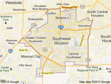
Southwest Houston
The term "southwest Houston" often refers to the area that opened in the years following World War II, when they were considered to be suburbs, such as Alief, Fondren Southwest, Meyerland, Sharpstown and Westbury. Alief is a large, ethnically diverse community which Houston began annexing in 1977. Fondren Southwest and Meyerland are centers of Houston's Jewish community. Sharpstown has large Hispanic and Asian American communities and was the first master-planned community in Houston. Also in the southwest is the Indian enclave, the Mahatma Gandhi District, informally known as Hilcroft. Westbury and Meyerland.
Spring Branch, Houston
Zip Codes: 77041, 77043, 77055, 77080
Spring Branch is a district in west-northwest Harris County, Texas, United States, roughly bordered by Tanner Road and Hempstead Road to the north, Beltway 8 to the west, Interstate 10 to the south, and the 610 Loop to the east; it is almost entirely within the City of Houston. Established by the Texas Legislature, the Spring Branch Management District exercises jurisdiction over the area. Several minor bayous run through the community, including Brickhouse Gully, Spring Branch (the neighborhood namesake), and Briar Branch, which drain into Buffalo Bayou in central Houston. Spring Lake is a large pond near the center of the neighborhood.

Stafford, Texas
Zip Codes: 77477, 77497
Stafford is a city in the U.S. state of Texas, within the Houston–The Woodlands–Sugar Land metropolitan area. The city is mostly in Fort Bend County, with a small portion in Harris County. As of the 2010 census, Stafford's population was 17,693, up from 15,681 at the 2000 census. As of 2015 the population had risen to an estimated 18,459.

Sugar Land, Texas
Zip Codes: 77478, 77479, 77487, 77496, and 77498
Sugar Land is a city in Fort Bend County, Texas, United States, within the Houston–The Woodlands–Sugar Land metropolitan area. It is one of the most affluent and fastest-growing cities in Texas, having grown more than 158 percent between 1990 and 2000. In the time period of 2000–2007, Sugar Land also enjoyed a 46.24% job growth. As of the 2010 census, the city's population was 78,817. In 2015 the population had risen to an estimated 88,156. Founded as a sugar plantation in the early mid-20th century and incorporated in 1959, Sugar Land is the largest city and economic center of Fort Bend County. Sugar Land is home to the headquarters of Imperial Sugar, and the company's main sugar refinery and distribution center were once located in the city.

Texas Medical Center, Houston
Zip Codes: 77030, 77054
Texas Medical Center (TMC) is a 2.1-square-mile medical district and neighborhood in south-central Houston, Texas, immediately south of the Museum District and west of Texas State Highway 288. Over fifty medical institutions, largely concentrated in a triangular area between Brays Bayou, Rice University, and Hermann Park, are members of the Texas Medical Center Corporation—a non-profit umbrella organization—which constitutes the largest medical complex in the world. The TMC has an extremely high density of clinical facilities for patient care, basic science, and translational research.

Upper Kirby
Zip Codes: 77005, 77027, 77048, 77098
Upper Kirby is a commercial district in Houston, Texas, United States. It is named after Kirby Drive, so indirectly takes its name from John Henry Kirby.
Upper Kirby contains many businesses, including restaurants. Upper Kirby is east of the Greenway Plaza, southwest of Neartown, north of the city of West University Place, and south of River Oaks.
Upper Kirby is considered to be in an area west of South Shepherd Drive, east of Buffalo Speedway, north of Bissonnet Street, and south of Westheimer Road.

Uptown, Houston
Zip Codes: 77024, 77056, 77057
Uptown (more commonly called The Galleria Area) is a business district in Houston, located 6.2 miles west of Downtown and is centered along Post Oak Boulevard and Westheimer Road (Farm to Market Road 1093). The Uptown District is roughly bounded by Woodway Drive to the north, the I-610 (West Loop) to the east, Richmond Avenue to the south, and Yorktown Street to the west. It covers 1,010 acres.
At 23.6 million square feet of office space, the Uptown District is the 17th-largest business district in the United States, comparable in size to the downtowns of Denver and Pittsburgh. The district is home to approximately 2,000 companies and represents more than 11 percent of Houston's total office space.

Westbury, Houston
Zip Codes: 77035
Westbury is a neighborhood in the Brays Oaks district of Southwest Houston, Texas, United States. It is located east of Bob White Road, north of U.S. Highway 90 Alternate (South Main Street), and west of South Post Oak Road, adjacent to the Fondren Southwest and Meyerland neighborhoods, just west of the southwest corner of the 610 Loop. Westbury was named as the 2007 "Best Hidden Neighborhood" by the Houston Press. Westbury was also listed in the 25 Hottest Houston Neighborhoods in the June 2013 edition of Houstonia Magazine.

Westchase, Houston
Zip Codes: 77042, 77057, 77063, 77077, 77082
Westchase is a business district and neighborhood in western Houston, Texas, bounded by Westheimer Road on the north, Gessner Road on the east, Houston Center Boulevard on the west, and Westpark Tollway on the south. The area is bisected by Beltway 8. Westchase is adjacent to Greater Sharpstown, the International District (which includes part of Chinatown), and the Royal Oaks Country Club subdivision. The area is immediately northeast of Alief. More than 1,500 businesses reside in Westchase; several are associated with the petroleum industry, for which Houston is considered a major capital. Major employers that have offices in Westchase include ABB Group, BMC Software, Chevron, Phillips 66, Dow Chemical, Petrochina, and Jacobs Engineering. The Westchase district is approximately 4.32 square miles in size, with 16.3 million square feet of office space contained in 118 buildings.

West University Place, Texas
Zip Codes: 77005
West University Place, often called West University or West U for short, is a city located in the U.S. state of Texas within the Houston–The Woodlands–Sugar Land metropolitan area and southwestern Harris County. As of the 2010 U.S. Census, the population of the city was 14,787. West University Place is surrounded by the cities of Bellaire, Houston, and Southside Place.
